

Route 66 (The Mother Road):
Route 66 (The Mother Road):
In 1926, a series of existing roads were renamed US Highway, Route 66. Paving started in 1920 before it was named Route 66 and continued until 1937 when paving was completed. At that time the road was 2,448 miles long starting in Chicago, Illinois and ending at Santa Monica, California, passing through 8 states.
Normally, highways with even numbers run east/west. Route 66 is unusual because from California to Oklahoma City it basically runs east/west but then starts turning north/south heading for Chicago, IL.
In 1939, novelist John Steinbeck called Route 66 “The Mother Road” as dust bowl farmers moved out west in hopes of better jobs. John Steinbeck wrote about this in his novel “The Grapes of Wrath”, Route 66 was also known as the Main Street of America, as it passed through many small towns along the way. Route 66 was one of the main routes to the western US before 1985.
Several movies and television shows were filmed on parts of Route 66 or inspired by it such as the movies “The Grapes of Wrath” (1940), “Easy Rider” (1969), “The Hitchhiker” (1986), “Thelma and Louise” (1991), “Cars” (2006) and the television series “Route 66” (1960-1964).
Route 66 was decommissioned in 1985 and is no longer part of the federal highway system, however approximately 85% of the road is still drivable. The route was also realigned several times, and many of the old alignments are still usable. Today Route 66 has been replaced by Interstate Highways I-55, I-44, I-40, I-15 and I-10.
Today Route 66 is a very long tourist attraction that people come from all over the world to see. People come to see what small town America was in the 1930’s through the 1970’s. The majority of travelers start in Chicago and drive west/southwest to Santa Monica. If planning a trip, I would suggest taking about 2 weeks so you will have time to see the sites and attractions.
This book is not intended to be a Travel Guide, and in some states, Route 66 is difficult to follow as the road names or state highway numbers change several times, remember that there is no Route 66 today. Most GPS will not find Route 66, because it no longer officially exists, so Route 66 maps or Travel Guides are the best way to go.
The purpose of this book is to see how the different towns, cities and states have survived the loss of Main Street USA and how things have changed for better or worse in not only the cities and towns, but also the tourist attractions along the way. Today all 8 states that Route 66 passes through have “Route 66 Associations” that are trying to save as much of the original historic highway and the buildings as possible.


Abraham Lincoln's Home in Springfield, IL


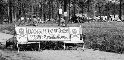
Times Beach, MO, circa 1983


"Marsh Rainbow Arch" Bridge
on Route 66, KS


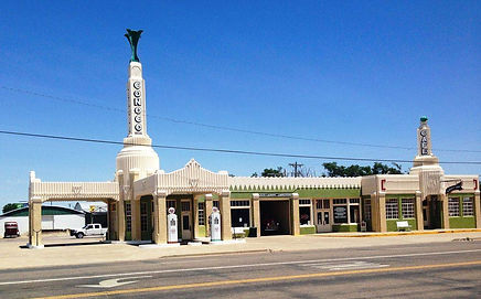
U-drop Inn/Tower Station
Shamrock, TX


Wigwam Motel, Holbrook, AZ


Roy's Motel, Amboy, CA

The Lincoln Highway:
The Lincoln Highway:
It is hard to talk about the history of the US Highway System without the Lincoln Highway coming up several times. In fact it is mentioned several times in this book before this chapter. Parts of the Lincoln Highway were also parts of The Historic Ukiah-Tahoe Highway and Historic US Highway 99W that I have written Travel Guides about in the past.
The Lincoln Highway was one of the earliest transcontinental highways for automobiles across the United States of America. Conceived in 1912 by Indiana entrepreneur and the builder of the Indianapolis Speedway, Carl G. Fisher. On September 14, 1913, The Lincoln Highway Association announced the route. It is surprising that the route did not include Detroit, MI as that was where the Lincoln Highway Association headquarters were located. The Lincoln Highway was formally dedicated October 31, 1913 with an estimated cost of $10 million. Most of the construction was finished in the late 1920’s and the Lincoln Highway ran coast-to-coast from Times Square in New York City, NY west to Lincoln Park in San Francisco, CA, originally through 13 states New York, New Jersey, Pennsylvania, Ohio, Indiana, Illinois, Iowa, Nebraska, Colorado, Wyoming, Utah, Nevada, and California.
In 1915, the "Colorado Loop" was removed, and in 1928, a realignment relocated the Lincoln Highway through the northern tip of West Virginia. The first officially recorded length of the entire Lincoln Highway in 1913 was 3,389 miles. Over the years, the road was improved and numerous realignments were made and by 1924 the highway had been shortened to 3,142 miles.
When the Lincoln Highway was built, most of the large cities near the route were connected, however two large cities, Detroit, MI and Chicago, IL were not on the Lincoln Highway although the highway ran just a few miles south of Chicago through Jollet, IL.
On September 1, 1928, the Lincoln Highway was officially marked and dedicated to the memory of Abraham Lincoln. On that day, at 1:00 p.m., groups of Boy Scouts placed approximately 3,000 concrete markers at sites along the route. They were placed on the outer edge of the right-of-way at each important crossroad and at other locations to assure each motorist that he was on the right road. Some of these markers still exist today.
The Lincoln Highway was gradually replaced with numbered designations after the establishment of the U.S. Numbered Highway System in 1926, with most of the route becoming part of U.S. Route 30 from Pennsylvania to Wyoming, and US Routes 40 and 50 in the west. After the Interstate Highway System was formed in the 1950s, the former alignments of the Lincoln Highway were largely superseded by Interstate 80 as the primary coast-to-coast route from the New York City area to San Francisco.
The Lincoln Highway had many realignments and multiple routes over the years and can be very hard to follow in some places. Unlike Route 66, the Lincoln Highway is not a large tourist attraction and as with Route 66, your GPS will likely not be able to follow the Lincoln Highway. This book is not intended to be a Travel Guide, more of just a “Quick Trip” to get some highlights.
In 1938, the original Lincoln Highway Association disbanded, as the road was no longer called the Lincoln Highway. The present day Lincoln Highway Association was formed in 1992 with a mission to identify, preserve and improve access to the remaining portions of the Lincoln Highway and its associated historic sites.
A good online map of the Lincoln Highway can be found at the Lincoln Highway Association’s web site www.lincolnhighwayassoc.org and each state has a local chapter except Colorado.


Grand View Hotel, circa 1920, PE


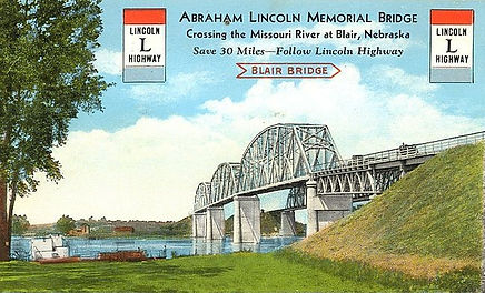
Lincoln Highway Realignment near Blair, NE


Lincoln Highway near Ely, NV


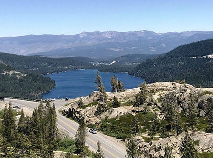
Lincoln Highway near Donner Summit, CA